Predicting NE monsoon is that easy ?
Our monsoon is one of the toughest matter to predict/conclude/find whatever it may be. It is not just so easy because the changing dynamics and the weather pattern makes it difficult to predict its behaviour. And adding to this the global climatic change also has its own impact on monsoon . So the title prediction involves my own observation of the weather dynamics and ongoing weather related events prior to the NE monsoon and in the midway of monsoon. This topic will be hit or miss type because nature has its own circle of fire and it can throw out anything from it.
NE Monsoon 2020.
Northeast monsoon is otherwise called Retreating monsoon winds (reversal winds of southwest monsoon). The dynamics of the northeast monsoon are ITCZ(Intra Tropical Convergence zone) , IOD(Indian Ocean Dipole) , MJO (Maden-Julian Oscillation) , Equatorial Rossby waves , Wind shear ,Convergence ,Divergence , Pacific ElNino/LaNina event , Sea Surface Temperatures , Driving Ridge and many other small phenomenons.
On the latest observations the IOD(Indian Ocean Dipole) is in negative values and will stay near the neutral values or in negative values. It is actually a positive thing , the IOD denotes the Sea surface temperatures in the Indian ocean basin(north) . If the IOD values are in positive side then the SST in Arabian sea will increase with decrease in temperature 🌡️ in the Bay of Bengal which inturn provides more number of system formation in the Arabian sea side than the Bay of Bengal side like in 2019(strongest recorded positive values of IOD in the History) .
Fig 2 shows IOD phenomenon
On the other hand if the IOD is in negative or in neutral values then the sea surface temperatures behave wise versa like BOB will have higher SSTs thaan the AB sea so ,the fromation of systems is highly concentrated in the BOB region . This year the IOD values are negative and can move to neutral values once the monsoon starts to progress.
Fig 3 shows the this week and this months sea surface temperature.
Fig 4 shows the trend values of IOD
Next the NiNo event ,this year LaNino phenomenon is emerging in the NiNo 3.4 region. On the basis of records most the LaNina years made the NE monsoon to fail but, here comes the king inraseasonal tropical wave MJO.
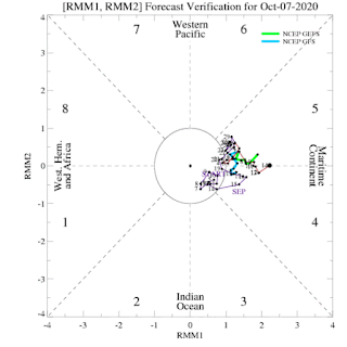
MJO is an intrasesasonal tropical wave that travels in the atmosphere over the warmer regions of Indian and Pacific oceans. It is an 30-90 day event with about eight phases in it . Phase 2, 3 & 4 belongs to the Indian ocean basin . MJO has two sides convective(triggers rain bearing clouds that feeds the developing system) and suppressive (dry conditions will prevail over suppressed region) . If LaNina event is present coupled with negative IOD and the emergence of the King MJO in the above said phases with a marginal or slightly higher amplitudes can produce good amount of rainfall during NE Monsoon.
Fig 5 shows the MJO's two phases
Fig 6 shows the GIF based movement of MJO
This year LaNina is present and IOD is in negative values both are in merely in favourable side but what the king MJO has to do is the whole surprise this monsoon .
On the analysis of weather charts the rainfall in this NE monsoon will be a average(normal) . Let us wait and watch that what is oncards for chennai this year.
Fig 7 shows the movement of MJO From the basins from Sep to Oct
Note: Based on my own prediction
Source for IOD & MJO image is taken from Australian meterological department for study.
Thank you ☺️


Comments
Post a Comment